Various photos of cycle facilities in the Netherlands.
Below you will see a variety of photos taken hundreds of kilometres apart in
the
Netherlands on various occasions when I've visited, showing the
remarkably high
overall standard of facilties. The people in the photos are my
family, friends,
or a few locals caught as they went by.
The Dutch understand about cycling and about cyclists. This is true not
only of the people at large but of the officials who design cycling
facilities in the Netherlands. They are also far less reluctant to
spend money on cycling than officials in the UK, or anywhere else in the English speaking world.
As a result, the Netherlands is an utter delight to cycle around. This
is true everywhere and all the time. It is not just a few isolated
spots which are good. This has to be experienced to be believed. In all
the times we've visited and now since we've lived here permanently, and
despite having travelled around much of the country by bike, we've yet
to spot a
single sign that says "Cyclists Dismount". The local equivalent should
read "Fietsers Afstappen" and I know what the sign is supposed to
look like
as I've seen a drawing illustrating this, but never have I seen one in
real life. I've also never seen "End of cycle route". These two signs
make up a pretty good proportion of cycle route signage in the UK.
Quite what Dutch people who visit the UK to cycle think of the
conditions is very hard to know. The tourist information from the UK
(in Dutch) is often remarkably glowing, and basically dishonest. I met
a couple with small children on the ferry to Harwich a few years ago
who thought they'd be able to cycle together to Stonehenge. The traffic
around Harwich is bad enough, let alone the A303 at the other end and
everything which comes between. They had an expectation first that
there would be a cycle path network and second that the signs on it
would guide them well enough that they'd barely need a map. That is a
reasonable expectation for any long cycling journey in the Netherlands.
That is how comprehensive and well planned the Dutch network is. There
is absolutely nothing in the UK to compete.
This web page dates from before we eventually left the UK for the
Netherlands. Since that time we have taken a lot more photos, some of
which are linked at the end of this webpage. Even these do not come
close to showing how remarkably good the network is. Some of the text
below
obviously reflects times before our move.
On my various visits, I've cycled well over a thousand miles in the
Netherlands. Virtually all on their cycle paths. I've done nothing
like that distance on British cycle paths, despite living here all the
time and doing the vast majority of my cycling in this country. There
really isn't much comparison so far as usefulness is concerned. Over
there, they are mostly very good. Well surfaced, wide, actually go
somewhere and have useful sign posts to let you know where you're
going. It's a proper usable network suitable for all. Here in the UK...
well, you know the
score.
Somewhere near Groningen. This is all cycle path, a river to the left,
road behind the hedge.
Heading south from Eindhoven to Valkenswaard. This bit is all cycle
path, bidirectional with a line down the middle. The road is to the
left past the trees.
The Oostvaardersdijk path in Flevoland between Almere and Lelystad - on
a good day. I got utterly soaked here before. Again, the bike is on the
path, the road is completely separate.
This photo was taken in 2003. I understand that this path was
considered not to be up to scratch and has now been upgraded.
A cake shop on the cycle path east of Amsterdam. There are a lot of
"fietscafes", a concept which has no equivalent in the UK. Appelgebak
met slagroom (baked apple cake with whipped
cream) is typical healthy fare. It's somewhere along Kanaaldijk, I
think (Google Maps).
Naughty cyclist (a local) about to enter the pedestrianised centre of
Eindhoven. This seems remarkably common, and no-one seems to get upset
about it. There is a way around the pedestrian area by bike, but some
cyclists go slowly through the pedestrian bit instead.
Cycle path through the forest South of Eindhoven, near Valkenswaard.
Note that though this is a leisure route well away from roads, it's
still well surfaced,
wide and not full of obstacles which you can't get around. It's
somewhere around here.
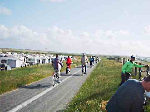
North Sea Route LF1 somewhere between Den Haag and Zandvoort. This is
the tail end of an enormous number of kids and commuters who went past
in one lump. This again is all cycle path and the road is somewhere the
other side of the caravans. This is around about here.
Typical sign post. These are actually all scenic routes as they are in
green. Similar red signs point out routes to get to places. These also
all happen to be LF (Landelijk Fietsroute) routes, a network
of
which provide wonderful leisure routes across the country.
Simon Nuttall somewhere on that North Sea route again. This is very
long and very pleasant. You can find it on Google Maps here.
Follow the reddish colour path which goes south from just to the right
of the circular building. That's the bike path shown above.
This photo was taken a few years ago. When I visited again in 2006 the
path had been upgraded. Remarkable - it was already better than
anything I'd ever seen in the UK before upgrading. A constant process
of improvement is normal, again something which is not seen in the UK.
Bike paths and a small part of the bike parking around the bus and
train station in Eindhoven. All of the cobbled area is bike path, not
road.
North West of Eindhoven, I think. The reddish path on the right side of
the trees is bike path, the other greyish one to the left is the road.
If you've got three holes under your bridge, then it obviously makes
sense to have two for bikes and pedestrians and one for cars. Somewhere
in Eindhoven. It was obviously old infrastructure even when this photo was taken in 2001, but that shows how long this has been going on.
A small shopping area. About the worst kind of cycle provision you tend
to get. The surface is a bit bumpy and it's relatively narrow. It's
still
segregated from both pedestrians and the road, though.
Bike route map somewhere in the forest near the Dutch / Belgian border.
Just a few hundred metres away is Belgium... and a Trappist Monastery
which brews excellent beer.
You use these maps by deciding which numbered points you need to go
through. So, our journey on this day started in Eindhoven, which is
slightly north of this map and we'd gone east just north of
Valkenswaard and then past points 32, 33 and 35 before arriving here at
point 36. Each point has a post with a map like this on it so you can
decide where to go next. The monastery is at point 217 or here on Google Maps.
Note that this doesn't even remotely try to show all the routes. It
just shows scenic routes. Every road has provision for cyclists in some
form, mostly by means of a fairly decent cycle path as shown elsewhere
on this page. Also note that it is truly international. The green
circles are in the Netherlands, the blue circles in Belgium.
Routes signposted in this way have been appearing all around the
Netherlands simply because they make good economic sense. Spending a
few hundred thousand Euros on these in a year has been shown to bring
millions of Euros in tourist spending. Decent cycle facilities cost a
fair bit, but the return on investment is also good.
West of Eindhoven going towards Oirschot. This is all cycle path. The
road is to the right out of shot separated by a grass verge. It's
somewhere around the Oirschotsedisjk / Eindhovensedijk.
Some miles further along the same path with the camera facing the
opposite direction.
The road is on the left of the trees and sign, the bike path on the
right. The sign reads "Look Out! Tank crossing place in 50m". Much to
my disappointment, no tanks crossed.
How to cross a dual carriageway with lights. No barriers, no stopping
in the middle. When you get a green you can ride right across, and the
delays aren't very long. The separate crossing to the left is for
pedestrians. This crosses 4 lanes of traffic this side of the central
reservation and I think three on the other side. All that with all the
cars stopped and in one go.
Compare this with British practice !
This is in Northern Eindhoven. I think I took the photo from the north
east of this junction facing south.
A dual carriageway for cycling. The road is the separate path to the
left, the pedestrians walk on the raised path to the
right, and cyclists
going in opposite directions have the two other paths as shown.
Northern Eindhoven around about here.
This way for more cakes...
Somewhere far from the coast in Flevoland. A really nice wide and
smooth cycle path apart from anything else.
Copious quantities of beer company sponsored cycle parking at a cafe in
the woods. Somewhere east of Eindhoven.
Part of the route to the cafe. Not a very wide path, but it's a purely
recreational one. Note the nice surface for cyclists and the horrible
surface for cars, and posts between them to prevent any motorists
trying to go along with one wheel on the cycle path.
Part of the remarkably desert like heath area East of Eindhoven, again
near the cafe.
There is a lot of this sort of narrow gravelly path in this area for
recreational cycling. You don't find it on well used routes. Note the
age of the oncoming cyclists. It's not at all uncommon to see older
people or children riding their bikes alone miles from anywhere. This
is an indicator of a healthy cycling culture.
A proper "safe route to school". The cycle path goes right past this
school, and most other schools. I'm not sure how you'd drive there.
Presumably there is a rear entrance to the school for deliveries.
Helmets ? Not here. Not even for babies.
Feel the width. May as well use the entire cycle path...
Coming into Almere. A fairly typical cycle path for this town. It's here on Google Maps. You can see
the red building.
The dual carriageway between Haarlem and Amsterdam. The cycle path
is to the south of this road, separated by a fair bit of grass and
amongst some trees. Due to the proximity of the big road this is hardly
the most pleasant place to cycle, but it's direct, and it's quite
comfortable. Keep going to the east and you'll eventually come to
Amsterdam. Further to the east, a complex junction.
This path serves a great number of businesses along this road. From
bottom to top you'll see cycle path, local access road (with speed
bumps), then the two lanes of the motorway then the train line.
Occasionally you have to ride on the access road. Never on the dual
carriageway. Another huge road junction
with cycle paths heading away in all directions. No ludicrous multi
stop crossings just because you're crossing a few lanes at once, either.
A petrol station in Zandvoort. See how the cycle path goes behind the
petrol station in a smooth arc rather than
requiring cyclists to give way when crossing the forecourt.
Finally a marvellous example of good cycle path planning here.
There is a slightly reddish cross roads which is the cycle path, a grey
one with traffic lights for cars. You can follow the cycle path for a
considerable distance in any direction withouth coming to any
particularly obvious obstructions or loss of priority to motor
vehicles. This is in Houten. Head north and you'll see how the path
provides easy access to the homes, head south and you'll see how it
works out into the countryside. Note how it crosses roads by stepping
back a little so that it is further from the road, but that this is
done in a smooth way. Go west and then north and you'll see how it gets
to the next town.
Some Dutch cycle promotion videos. Very amusing, and they show cycling
without being "worthy":
More photos and articles about cycling in the Netherlands